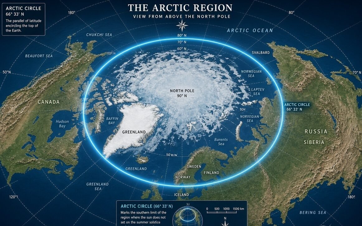
Today, Monday, August 17, 2026, I looked closely at the map of the Arctic Circle, and one simple line suddenly felt much more interesting than it first appeared. It is not a border made by a country. It is an imaginary line near 66°33′ north latitude, and it wraps around the far north of our planet.
When I first see an Arctic Circle map, I usually think it is just a cold place marked in blue. But the map tells a bigger story. It shows where Earth begins to behave very differently, with long summer daylight, dark winter periods, frozen seas, wildlife, remote towns, and huge stretches of land and ocean.
The Arctic Circle is not exactly fixed forever, either. I found that its position changes slightly because Earth’s axis slowly changes its tilt over long periods. So even that famous line has a tiny movement of its own.
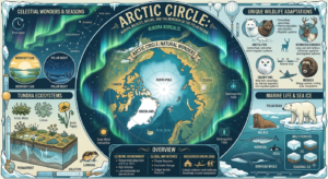
On a normal world map, the Arctic Circle looks like a curved line near the top. Yet on a globe, I can see why it is called a circle. It runs around the planet, roughly 66 degrees and 33 minutes north of the Equator. Everything farther north enters the broad geographic zone usually called the Arctic. NOAA describes the Arctic in the strict geographic sense as the area north of approximately 66°34′ N.
That number can look boring at first. I thought so too. But it explains one of the strangest events on Earth. Around the Arctic Circle, there can be a period when the Sun stays above the horizon for 24 hours during the summer solstice. In winter, the opposite happens, and the Sun can remain below the horizon for a full day.
That is why the map is more than a picture. It is almost like a warning sign from nature. Cross the line, and the amount of daylight can become very unusual.
The exact Arctic Circle is commonly given as about 66°33′ north, although different sources may round the figure slightly. Modern calculations put the position close to 66°33′50″ N. The difference is tiny on a classroom map, but it matters when scientists and mapmakers work with exact coordinates.
I also noticed something surprising when looking at the countries around the line. The Arctic Circle passes through parts of Norway, Sweden, Finland, Russia, the United States through Alaska, Canada, Greenland within the Kingdom of Denmark, and Iceland. These are commonly identified as the eight Arctic states connected with the region.
Russia covers a huge section of the northern landscape. Canada also has enormous Arctic areas. Greenland appears on the map like a giant frozen island between the Arctic and Atlantic oceans. Alaska reaches deep into the northern zone too.
Then there is Scandinavia. Norway, Sweden, and Finland bring the Arctic Circle surprisingly close to roads, villages, tourist areas, and working communities. So the Arctic is not simply an empty white place at the top of the map. People live there, travel there, study there, and have lived there for generations.
I find Greenland especially striking on an Arctic map. Much of the island is covered by the Greenland Ice Sheet, and its position makes it one of the most recognizable pieces of the far north. The map makes Greenland look enormous, and that visual impression changes depending on the type of map being used.
That part is important because maps can sometimes trick our eyes. A flat world map cannot show a round Earth perfectly. Areas close to the poles may look stretched or enlarged on some common map projections. So when I compare an Arctic map with a globe, the shapes can look different even though the geography has not changed.
The Arctic Circle itself is an imaginary geographic line. It does not create a physical wall. There is no giant frozen fence standing there. A traveler can cross it without feeling a bump under their feet.
Still, the line has a powerful meaning. It marks the approximate southern limit where the special polar-day and polar-night effects can occur. That makes the Arctic Circle one of the most famous latitude lines on Earth.
The map also points toward the Arctic Ocean. This ocean sits around the North Pole and is surrounded by northern land areas. NOAA’s geographic description shows how the Arctic Ocean’s boundaries connect with northern North America, Greenland, Iceland, Scandinavia, and Eurasia.
I can almost imagine the map moving as I follow the line eastward. It crosses the northern part of Scandinavia. Then it runs across Russia. It reaches Alaska. From there it continues through Canada and around Greenland and the wider North Atlantic region.
Every section has a different landscape.
In northern Norway, the Arctic Circle can be reached by travelers. In Sweden and Finland, the line passes through forests, lakes, roads, and settlements. Farther east, Russia contains vast northern territories. In Alaska and Canada, the Arctic landscape becomes enormous and remote.
The farther north I imagine going, the more the scenery changes. Trees become scarce in many areas. Tundra spreads across the land. Snow and ice dominate parts of the landscape for long periods. The sea itself can freeze seasonally or for longer periods, depending on location and conditions.
But the Arctic is not lifeless.
Polar bears move across sea ice and coastal areas. Arctic foxes survive in harsh conditions. Reindeer and caribou travel across northern landscapes. Seals live in Arctic waters, while whales move through the ocean. Birds also arrive during warmer months when food becomes available.
That makes an Arctic Circle map useful for more than tourists. Scientists use maps to understand where animals live, where sea ice changes, and how the environment is shifting.
The climate story is becoming even more important. The Arctic is experiencing rapid environmental change, and warming in the region has been especially strong. WWF notes that the Arctic is warming at roughly twice the global average, with changes affecting both land and sea.
I think that is where an ordinary map becomes a much bigger news story.
A map from years ago can show the same latitude line as today’s map, because the Arctic Circle is based on Earth’s geometry. But the environment around that line can change. Sea ice can expand and shrink. Snow conditions vary. Permafrost can thaw. Wildlife patterns can shift.
The line itself is not melting. The world around it is changing.
Another thing that catches my attention is the difference between the Arctic Circle and the broader Arctic region. They are not always exactly the same thing. Scientists, governments, and organizations may use different definitions depending on what they are studying. NOAA notes that the Arctic can have several definitions for scientific and political purposes.
So when I search for an Arctic Circle map, I have to ask what kind of map I am actually looking at.
One map might highlight the 66°33′ latitude line. Another might shade the whole Arctic region. A third might show countries and borders. A scientific map could show sea ice, temperature, wildlife, shipping routes, or research stations.
That is why two Arctic maps can look completely different while both being correct.
The Arctic is home to millions of people across its wider northern regions. The Arctic Council identifies eight Arctic states and says more than four million people live in the northern areas of those states.
Indigenous peoples have lived across the Arctic for thousands of years, developing cultures, knowledge, languages, food systems, and ways of traveling that fit difficult northern environments. A simple political map can easily hide this human history.
The Arctic Ocean is also becoming increasingly important in global discussions about climate, science, shipping, resources, and international cooperation.
Yet the map still has that quiet line running through everything.
The Arctic Circle looks simple because it is only one imaginary circle. But it connects astronomy, geography, climate, wildlife, travel, science, and human life in one strange ring around the planet.
When I look at it now, I no longer see just a line at the top of a map.
And I see a place where environmental changes are becoming impossible to ignore.
The most exciting part is that the map does not tell the whole story.
It only gives me the starting point.
The real Arctic begins when I follow that line into the landscape, across frozen water, through northern forests, over tundra, past remote communities, and toward the North Pole.
That is why the map of the Arctic Circle continues to attract attention. It looks like a simple drawing, but behind that circle is one of Earth’s most unusual regions.
And perhaps the strangest detail is this: the Arctic Circle is imaginary, yet everything it helps explain is very real.
✍️ Written by Vimal Bhagat
🌎 Sharing fresh news, trending stories & interesting updates from around the world.
💙 Read more: arcticcircle.us

Pingback: Arctic Circle Interactive Map: The Digital Map That Lets Me Explore the Frozen North Like Never Before — Arctic Circle