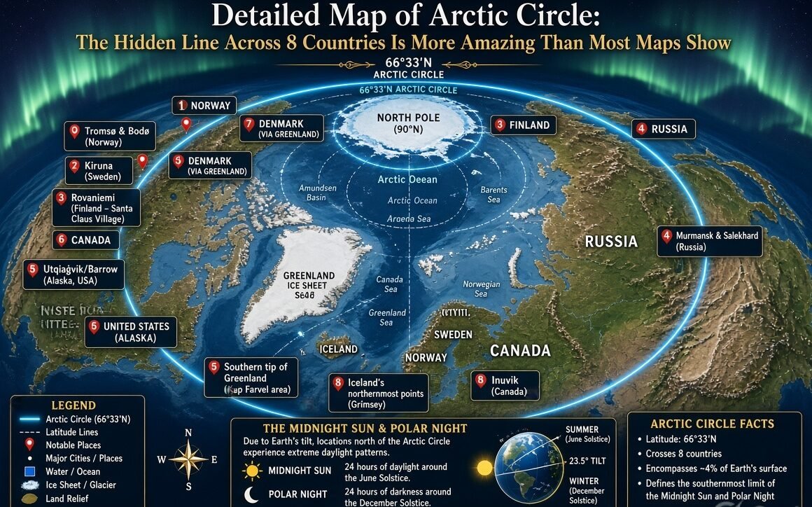
On Friday, August 21, 2026, the detailed map of Arctic Circle is getting fresh attention as travelers, students, and map fans look again at the strange line around the top of the world. I looked at the map and found it is not just a simple blue circle on Earth. It crosses land, sea, islands, towns, and some of the coldest places on our planet.
The Arctic Circle sits at about 66°34′ north latitude. That number sounds small, but it marks a huge geographic story. The line runs for roughly 15,966 kilometers around the Northern Hemisphere, according to a recently reviewed mapping source.
I was surprised by one thing first. The Arctic Circle is not the same as the whole Arctic region. It is a geographic line, while the wider Arctic can be defined in several different ways. A map can therefore show the circle and still leave a much larger northern world outside its simple boundary.
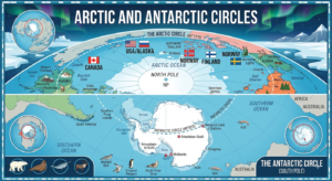
The line starts to feel real when you follow it from west to east. It moves across northern parts of North America, Greenland and the Nordic countries. Then it travels through the enormous northern lands of Russia before heading back across the Arctic Ocean. It is one long trip, and the map makes that journey look almost unbelievable.
The Arctic Circle crosses eight countries. They are Norway, Sweden, Finland, Russia, the United States, Canada, Denmark through Greenland, and Iceland through the island of Grímsey.
I can almost imagine tracing the line with my finger. First comes the northern part of Scandinavia. Then the route moves into Finland. After that, the line reaches Russia, where the northern landscape becomes enormous. It later crosses North America, touching Alaska and Canada, before reaching Greenland and the North Atlantic area.
Norway gives the map a famous starting point for many visitors. The circle crosses Nordland County. Near Saltfjellet, travelers can visit the Arctic Circle Centre, which marks the line beside the E6 highway. The town of Mo i Rana is also close to the circle.
Sweden appears next on many west-to-east maps. The Arctic Circle crosses Norrbotten County. The line passes north of Jokkmokk, an important place in Sámi culture and history. I find this part of the map especially interesting because the line is not only about geography. People have lived, traveled, traded, and worked in these northern landscapes for generations.
Finland brings another famous name. Rovaniemi sits almost directly on the Arctic Circle and has made the line a major part of its tourism identity. Visitors come to see the marker, experience northern seasons, and explore Lapland. The map suddenly becomes more than a science lesson there. It becomes a travel plan.
Russia is the giant section of the story. The circle crosses a massive stretch of northern Russia, from the west toward Chukotka in the far east. A map makes this distance easy to miss because the whole country is already so large. But once the Arctic Circle is drawn across it, the scale becomes much clearer.
I noticed another surprising detail. Murmansk is north of the Arctic Circle and is one of the best-known large cities in the region. It lies around 69°N. Its port remains important because ocean currents help keep the area comparatively accessible compared with many other high-latitude locations.
The United States enters the story through Alaska. The Arctic Circle crosses northern Alaska, where huge distances separate communities. Roads are limited in many areas, and the landscape can change dramatically between coastal zones, tundra, mountains, rivers, and interior regions.
Canada adds another enormous part to the map. The northern Canadian landscape contains vast territories, islands, lakes, rivers, and remote communities. Natural Resources Canada publishes circumpolar and Canadian reference maps that show major geographic features and the Arctic Circle.
Greenland is another major feature. It is an autonomous territory within the Kingdom of Denmark, and much of the island lies far north of the circle. The map shows Greenland as a huge landmass surrounded by cold seas and covered largely by the Greenland Ice Sheet.
Then there is Iceland. This part can confuse people. The main island of Iceland is south of the Arctic Circle, but the line reaches the small island of Grímsey. That tiny island is therefore an important point on maps of the Arctic Circle.
The map also shows something that is easy to forget. Much of the Arctic Circle is not over land. It travels across the Arctic Ocean and other northern waters. So when someone looks at a world map and sees a neat line, the reality beneath that line can be ocean, ice, coastline, tundra, mountain country, or settlement.
The Arctic Circle is famous because of sunlight. At the June solstice, locations on and north of the circle can experience the midnight sun. The Sun may remain above the horizon for at least part of a 24-hour period. During the December solstice, the opposite happens. Some places can experience a period when the Sun does not rise. This is known as polar night.
I think this is where the map becomes almost magical. A line on paper is connected to something people can actually see in the sky. Go north, and the period of continuous daylight becomes longer during summer. Go farther north again, and the period of winter darkness also grows.
The exact position of the Arctic Circle is not perfectly fixed forever. Earth’s axial tilt changes slowly, so the location of the polar circles shifts over time. A recent map reference places the Arctic Circle around 66°33′50″N, or approximately 66.5606° north.
That small movement might sound like nothing. But maps are precise tools. Even a slowly changing latitude matters when scientists, surveyors, educators, and mapmakers describe the boundary.
A detailed Arctic map also needs more than country names. It can show towns, rivers, lakes, mountains, coastlines, islands, roads, and ocean areas. The British Antarctic Survey has produced a map of the Arctic north of 60°N showing populated places, rivers, lakes, shaded relief, and towns.
This wider map is useful because the Arctic Circle itself is only one line. The region around it contains many geographic layers. Some places just south of the line can feel extremely northern, while places farther north can have very different conditions depending on altitude, ocean currents, sea ice, and local geography.
Climate is another big part of the picture. The Arctic is generally cold, but it is not cold in exactly the same way everywhere. Coastal Norway, for example, has a different climate from interior Siberia. Northern Alaska differs from Greenland. The Canadian Arctic islands have their own patterns too.
The map therefore tells only part of the story. I can see where a place is, but I also need weather data to understand what life there feels like.
The Arctic landscape can be dramatic. In some places, trees disappear as the environment becomes too cold or the growing season too short.
Wildlife follows these landscapes. Polar bears live across parts of the Arctic, especially around sea-ice environments. Arctic foxes, reindeer and caribou, seals, walruses, whales, and many bird species are also connected with northern ecosystems.
But animals do not care about a line drawn on a map. A polar bear does not stop at 66°34′N and say, “That is the boundary.” Nature works through habitats, food, temperature, sea ice, and seasonal movement.
People also do not live according to a single line. Indigenous peoples have deep connections with Arctic lands and waters. Sámi communities live across northern Norway, Sweden, Finland, and Russia. Inuit communities live across parts of Canada, Greenland, and Alaska. Their histories and knowledge are an essential part of understanding the Arctic.
The Arctic Circle map also helps explain why the region matters economically. Northern areas contain important shipping routes, minerals, energy resources, fisheries, tourism destinations, research stations, and strategic locations.
Russia has a particularly large Arctic coastline. The Woods Hole Oceanographic Institution notes that Russia accounts for about 53% of the Arctic coastline.
Shipping is another reason the map gets attention. As sea-ice conditions change seasonally, northern maritime routes can become more accessible for some periods. But Arctic travel is still difficult and dangerous in many areas. Ice, storms, cold temperatures, limited infrastructure, and enormous distances remain serious challenges.
Tourists usually see a friendlier side of the map. Rovaniemi attracts visitors looking for Arctic experiences. Northern Norway is famous for the midnight sun and northern lights. Greenland offers huge landscapes and ice-covered scenery. Alaska and northern Canada offer wildlife and wilderness experiences.
I would not call every place easy to reach, though. A dot on a map can look close, while the real journey may require planes, boats, specialized vehicles, or long road trips.
One of the most interesting cities on the broader Arctic map is Tromsø in Norway. It is north of the Arctic Circle and has become a major center for tourism, research, and northern culture. Other northern settlements appear much smaller, and some are extremely remote.
The detailed map also reveals how different the Arctic is from the simple picture many people have in their heads. It is not one giant empty sheet of white ice. And yes, there are huge stretches where almost nobody lives.
The Arctic Circle itself is also different from the commonly used “Arctic region.” Some scientific and political maps use boundaries such as 60°N or other environmental definitions. Natural Resources Canada, for example, provides a North Circumpolar Region map covering areas north of 60° latitude.
That means two Arctic maps can look different and still both be correct. One may focus on the geographic Arctic Circle. Another may show the wider circumpolar Arctic.
For students, the easiest way to understand the map is to remember one number: about 66.5°N. Then remember the eight countries crossed by the line. After that, look for major nearby places such as Rovaniemi, Murmansk, northern Norwegian settlements, northern Canadian communities, Alaska, Greenland, and Grímsey.
For travelers, the map tells another story. It shows where the famous northern experiences are located. The farther north you travel, the stronger the seasonal difference can become. Summer daylight can seem endless. Winter darkness can feel just as unusual.
For scientists, the map is a starting point. They need much more information. Satellite images, sea-ice measurements, weather stations, ocean observations, wildlife tracking, and long-term climate records all add detail.
For me, the biggest surprise is how much information can hide inside one simple line. At first, the Arctic Circle looks like a circle around the top of Earth. Then I look closer. Countries appear. Cities appear. Islands appear. Oceans appear. And suddenly the line feels like a road through one of the most unusual regions on Earth.
The newest mapping resources also make the Arctic easier to explore digitally. NOAA maintains an Arctic Circle geographic layer, while other organizations provide detailed political and physical maps.
So the next time I see a detailed map of Arctic Circle, I will not see only a thin boundary. I will see a moving geographic marker crossing eight countries and huge ocean areas. I will see communities, wildlife, ice, mountains, rivers, and long winter nights.
And maybe that is the real surprise. The Arctic Circle looks simple from far away, but zoom in and the story gets huge. The line is only the beginning.
✍️ Written by Vimal Bhagat
🌎 Sharing fresh news, trending stories & interesting updates from around the world.
💙 Read more: arcticcircle.us